
Name:
19-V19-US2092
Latitude: N37°50.423'
Longitude: W119°12.369'
Elevation: 3393m
Location: Parker Pass
GPS Accuracy: 3m
Direction: 340
Photo Date: 7/14/2008
Time: 12:00pm
Latitude: N37°50.423'
Longitude: W119°12.369'
Elevation: 3393m
Location: Parker Pass
GPS Accuracy: 3m
Direction: 340
Photo Date: 7/14/2008
Time: 12:00pm

Vale (1994) Reference: print
Photo Year: N/A
No
Photo Available
USGS Reference: 2092
Photographer: G.K. Gilbert
Year: 1903
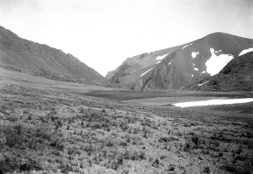
Caption: Yosemite National Park, California. Head of Parker Canyon, viewed
from Parker Pass. On the right is the margin of a small glacier under
Koip Peak. 1903.
Photo Credits: N.Wasserman (2008); Vale & Vale (1994). University of Utah Press; USGS
Inquires
- email the photographer